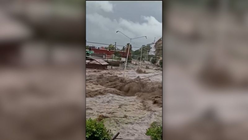
Hilary has weakened to a post-tropical cyclone that’s still bringing life-threatening flooding and gusty winds to much of the Southwest US, leaving streets like raging rivers and residents ordered to leave their homes.
After hitting Southern California on Sunday as a tropical storm – the state’s first since 1997 – Hilary early Monday was moving over central Nevada, about 390 miles north of San Diego, packing sustained winds of 35 mph with higher gusts, the National Hurricane Center said.
Live updates: Hilary brings major flood risk to California
Continuing rain is expected to cause life-threatening or catastrophic flash, urban and arroyo flooding in some places, including landslides, mudslides and debris flows. Localized flooding is expected into Tuesday morning across northern portions of the Intermountain West.
“Areas that normally do not experience flash flooding will flood,” the National Weather Service said. “Lives and property are in great danger through Monday.”
Flood watches are in effect for more than 25 million people from Southern California to northern Idaho. Strong and gusty winds are expected to persist across portions of the western US Monday, particularly in and near areas of higher terrain. All coastal tropical storm warnings have been discontinued.
“With what we’re expecting, it may overwhelm us,” he added.
Flooding, mudslides and downed trees and wires already are widely reported across Southern California.
In Palm Springs, 911 lines were down Sunday night as roads turned into rivers. Vehicles hours earlier were seen driving through floodwaters, with their wheels completely submerged.
To the west, Los Angeles and Ventura counties saw “considerable damage” Sunday night amid reports of life-threatening flash flooding, and rock and mudslides, the National Weather Service said, adding up to half an inch of rain could fall per hour.
Cars were stuck in floodwaters in the Spanish Hills area, the National Weather Service reported.
And as Hilary triggered flood warnings across Los Angeles, a magnitude 5.1 earthquake on Sunday afternoon shook the area and other parts of Southern California, the United States Geological Survey said.
Roads deluged with mud and water
Once a hurricane, Hilary weakened as it made landfall Sunday in Mexico – where at least one person died – then crossed into the Golden State. The storm’s center was roughly 10 miles southeast of downtown Los Angeles around 8 p.m. local time Sunday, moving north with weakened 45-mph winds, according to the hurricane center.
As the storm barreled through, covering roadways with debris and water, roads were blocked across Southern California by Sunday night. A section of Interstate 8 in Imperial County, east of San Diego, was closed Sunday after boulders came loose from an adjoining slope and fell into the road.
In San Bernardino County, a stretch of State Route 127 covered in floodwaters was closed, while a section of Interstate 15 was shuttered in Barstow because of downed power lines after a lightning strike, authorities said.
Residents of the Serrano Square neighborhood in San Bernardino County’s Yucaipa were ordered to evacuate Sunday night, while those in the community of Forest Falls and on Oak Glen Road were told to shelter in place as mud and debris blocked a nearby roadway.
Crews across the region Sunday evening rescued people caught in the storm, including at least nine in a riverbed area in San Diego. “Crews are still looking for more people who may need help. #riverrescue,” San Diego Fire-Rescue said.
And Ventura County firefighters searched the Santa Clara River for people trapped in the waters on Sunday night, videos show.
The storm led to other disruptions across Southern California, with many parks, beaches and other locations closed as officials called on residents to stay indoors.
The Los Angeles Unified School District – the nation’s second largest school district – will be closed Monday because of the storm. So will campuses in the Pasadena Unified School District and the San Diego Unified School District, officials there announced.
Nearly a month’s worth of rain in 1 hour
California had been preparing for difficult conditions, positioning first responders across Southern California to brace for water rescues in flood-prone areas like wildfire burn scars and deserts amid fears areas unaccustomed to rain could suddenly receive a year’s worth or more, triggering flash floods and landslides.
Already, rainfall totals have been significant:
Daily and monthly rainfall records were broken Sunday, with 1.53 inches falling in downtown Los Angeles, 1.56 inches in Long Beach and 2.95 inches in Palmdale, according to the weather service.
Palm Springs received half a year’s worth of rain in just a six-hour period, with 2.27 inches recorded at the Palm Springs Airport on Sunday, according to the National Weather Service.
Death Valley saw triple its average August rainfall in just a few hours Sunday morning. Nearly a month’s worth of rain fell in one hour on Sunday. It normally receives an average of 0.21 inches of rain the entire month of August, but the Furnace Creek observation site reported 0.63 inches since Sunday morning.
Santa Clarita, about 30 miles north of Los Angeles, experienced steady rain for about ten hours, with the storm dropping well over four inches of rain on the valley. Parts of Sand Canyon Road could be seen falling into rushing water.
ATTN DRIVERS: State Route 127 is now closed between Baker Blvd. in Baker (San Bernardino County) and Tecopa Hot Springs Road (Inyo County) due to flooding. @Caltrans9 maintenance crews are on scene. pic.twitter.com/fvcI9Vhss3
— Caltrans District 9 (@Caltrans9) August 21, 2023
By late Sunday, the National Weather Service had sent a mass alert to cell phone users in parts of the county saying, “Do not attempt to travel unless you are fleeing an area subject to flooding or under an evacuation order.”
San Bernardino Fire Battalion Chief Mike McClintock said evacuation orders are meant to help residents escape areas that may face serious flooding, and that warnings should be heeded immediately.


